
Overview
The Tateyama Kurobe Alpine Route connects Toyama Prefecture and Nagano Prefecture across roughly 90 kilometers of high mountain country. It is not a single road in the normal sense, but a stitched-together passage of seven transport modes — cable cars, ropeways, trolley buses, electric buses, and rail or bus connections — which makes the journey feel less like transit and more like a sequence of elevations, tunnels, and sudden openings onto raw alpine texture. That is the point. You move through the mountains rather than around them.
For a day trip, the route works cleanly in either direction. A classic itinerary starts in Toyama, continues via Tateyama Station and Murodo, then ends in Shinano-Omachi in Nagano, with the reverse direction also possible. The highest point is Murodo, at about 2,450 meters above sea level, and that altitude shapes the whole experience: cooler air, lingering snow, and a body that notices the climb even when the timetable is doing all the work. Check schedules and ticketing ahead of time. This is not the place to improvise. Seasonal fares, transport changes, and possible reservations all matter here, and the official information is the thing to trust.
How the day trip is put together
If you are approaching the route from Toyama, Toyama Station is the practical starting point. It is reachable from Tokyo by Hokuriku Shinkansen in about 2 hours and 8 minutes, which is fast enough to make the whole outing feel oddly available for a one-day mountain crossing. From there, the Toyama Chiho Railway to Tateyama Station takes about 53 minutes on a regular local train and costs around 1,420 yen, or 1,280 yen with an IC card; limited express trains add a surcharge. That is the sort of logistics detail that matters because this route rewards clean planning. The Japanese word 予約 (yoyaku, reservation; booking), meaning a reservation, can matter for certain tickets and dates, so it is worth checking before you go.
The route itself is a study in transitions. One segment lifts you. Another carries you through. Another drops you into a tunnel or releases you into open air. This is not a drive-you-there attraction; it is a chain of choices assembled by geography. The stations are functional, the views are the prize, and the day moves in clicks rather than miles, even though the full span is substantial. If you like travel that makes the body slightly more alert, this is good material.
What makes the route matter
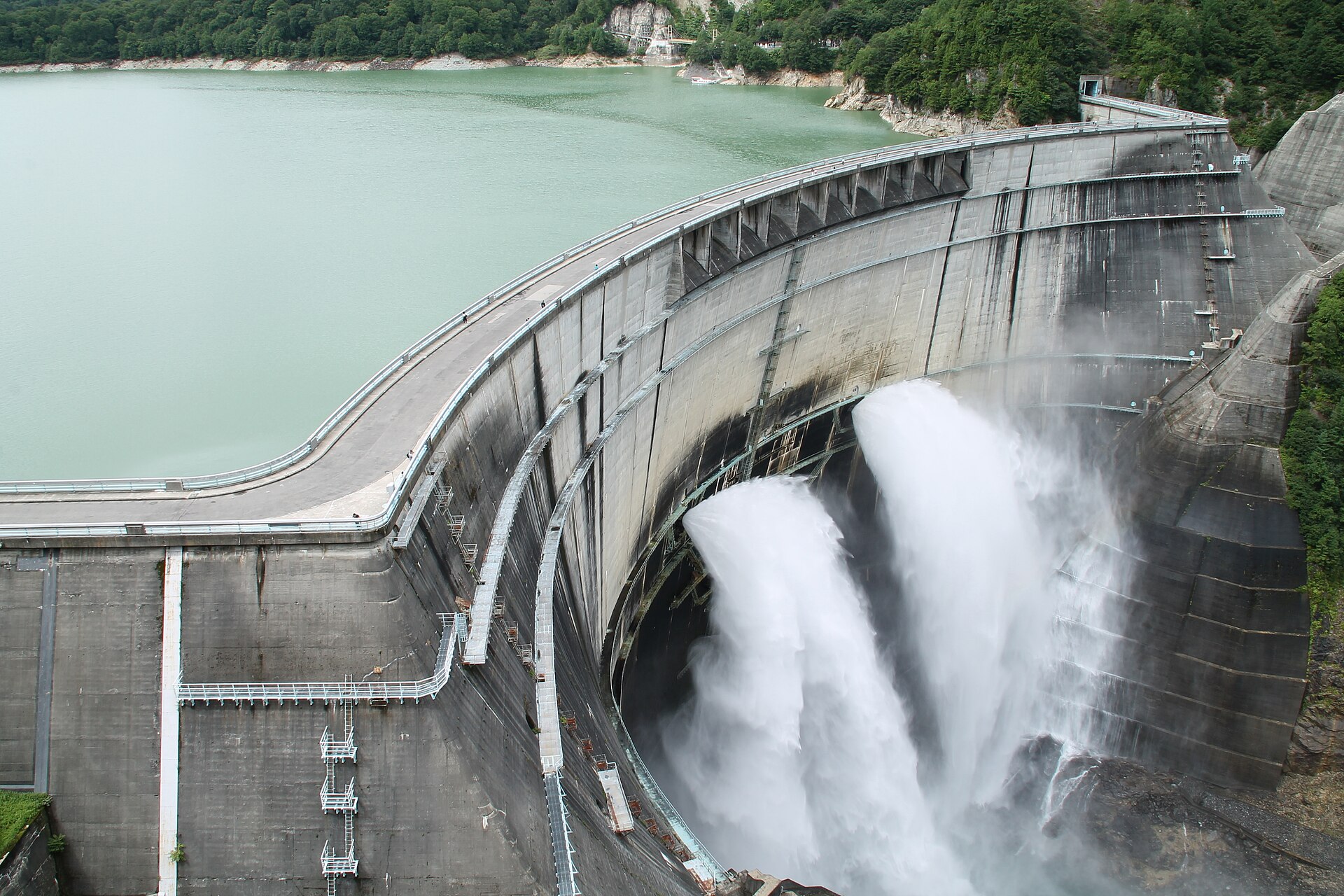
Several things anchor the Alpine Route in the Japanese travel imagination. First, there is the scale: a 90-kilometer crossing through steep country that is made possible by human engineering without flattening the landscape into comfort. Second, there is the Kurobe Dam, a major highlight of the route. One source states that it stands 186 meters high and was completed in 1963, which helps explain why it carries such weight in discussions of modern infrastructure in Japan. It is an object of utility, but also of line and force. You feel the ambition of it.
Third, there is the seasonal drama. The route officially opens around mid-April and closes in late November, with peak season in May. That window matters because the mountain does not behave like a city attraction. The snow, light, and crowds all move on their own schedule. The famous Snow Corridor, or Yuki no Otani, is typically open in spring and is known for towering snow walls. For the 2026 season opening, reports put the wall height at about 12 meters, while the historical record remains around 20 meters, set in 2000. Not 21. The details count here.
The route also has a clear learning angle for readers who like Japanese travel vocabulary. Tateyama Kurobe Alpine Route als Tagesausflug kanji is the kind of search phrase that points people toward the route’s official Japanese naming, while Tateyama Kurobe Alpine Route als Tagesausflug japanisch lernen is useful if you want to recognize the place names and transport terms in Japanese maps, timetables, and station signs. The practical word to know is 振り仮名 (furigana, phonetic reading aid written alongside kanji), the reading aid often seen alongside difficult place names. On a route with multiple transfers, that kind of small support can save real time.
The Snow Corridor and the best timing
The Snow Corridor is the route’s most photographed stretch, and it is also the one that demands the most timing discipline. The snow walls are only in optimal condition for a few weeks, so if you want the cleanest version of it, do not treat spring as a vague season. Treat it as a narrow opening. One source recommends arriving early in the morning, roughly between 8 and 10 a.m., when the light is better and the crowds are smaller. That is sound advice. The mountain has a way of looking cleaner before the day fills up.
Even in late April, Murodo can still have snow and temperatures near freezing, so warm clothing and sunglasses are not optional extras. They are part of the route. The alpine sun is bright, the wind can be sharp, and the snow reflects more light than your eyes will thank you for. Wear the lightest shoes possible, but not foolish ones. That balance matters more here than it does on a casual urban day out.
If you are comparing season planning across the wider region, the Alpine Route also fits into broader mountain travel patterns in central Japan, where weather, altitude, and transport schedules all shape the experience together. For readers tracking dates and opening periods, this Tateyama Kurobe Alpine Route day trip guide gives a useful frame for how the crossing works as a single-day outing, while the 2026 opening period is confirmed on the operator’s official site with the full-line season running from April 15 to November 30, 2026.



Where to experience it in Japan
You experience the route in Toyama and Nagano, not in a single town or viewpoint. That is part of the appeal. Start from Toyama Station if you want the smoothest rail connection from Tokyo, then continue through the mountain chain toward Tateyama Station, Murodo, the Kurobe Dam area, and onward to Shinano-Omachi. If you prefer the opposite direction, reverse the logic and begin in Nagano. Either way, the attraction is the corridor itself: the sequence of transport, the changing altitude, the snow line, and the sense that Japan still contains places where infrastructure and landscape are in direct conversation.
If you are planning around current-season reporting, it helps to cross-check official notices with route guides such as the one on the 2026 reopening and snow-corridor coverage. For a broader seasonal context, this Snow Corridor opening report and the related seasonal reopening article are useful companions, especially if you are trying to line up dates with weather and transport availability. The route rewards that kind of attention. More soon.
Related Japan travel ideas
If the Alpine Route appeals because it combines moving parts, altitude, and a strong sense of place, you may also like other mountain or infrastructure-led day trips in Japan where the journey is the main event. The Kurobe Dam segment in particular has the same sort of austere appeal as a well-made hike: no fuss, just scale. The route is also a good reminder that Japan travel is not always about temples, shopping streets, or famous food. Sometimes it is about climbing through weather. That is enough.
- Plan ahead for seasonal schedules and possible reservations.
- Start early if you want better light at the Snow Corridor.
- Expect cold conditions at Murodo, even in spring.
- Choose Toyama-to-Nagano or the reverse based on your wider itinerary.
Frequently Asked Questions
Can the Tateyama Kurobe Alpine Route really be done in one day?
Yes. The route can be completed as a day trip without a car, and a common itinerary runs from Toyama through Tateyama Station and Murodo to Shinano-Omachi, with the reverse direction also possible.
When does the route open and close?
The route opens around mid-April and closes in late November. For 2026, the full-line operating period runs from April 15 to November 30.
How high is Murodo?
Murodo, the highest point on the route, sits at about 2,450 meters above sea level.
What is the Snow Corridor?
The Snow Corridor, or Yuki no Otani, is the spring section known for its tall snow walls. It is only in optimal condition for a few weeks, so timing matters.
Do I need to book ahead?
You should check schedules and ticketing before traveling, because fares, timetables, and reservations can change with the season.
Sources
- Tateyama Kurobe Alpine Route official opening information — https://alpen-route.com/en/transport/opening.html
- Ekitan: Tateyama access guide — https://ekitan.com/en/article/tateyama
- Tabi Mag: Alpine Route Snow Corridor coverage — https://tabi-mag.jp/alpenroute-open/
